Descripción
Extends the WordPress Plugin Leaflet Map with Leaflet Plugins and other functions.
Functions
-
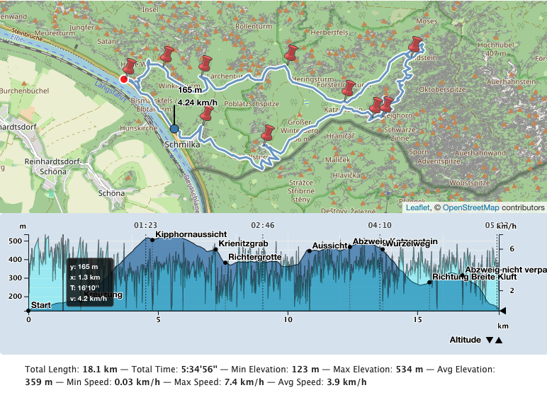
Create an elevation chart profile of a track. There are also acceleration, slope, speed and tempo chart profiles. You can also place multiple tracks on one map.
-
By default Leaflet Map uses tiles from openstreetmap.org or from the tile servers you configured. You can use more and switch between them.
-
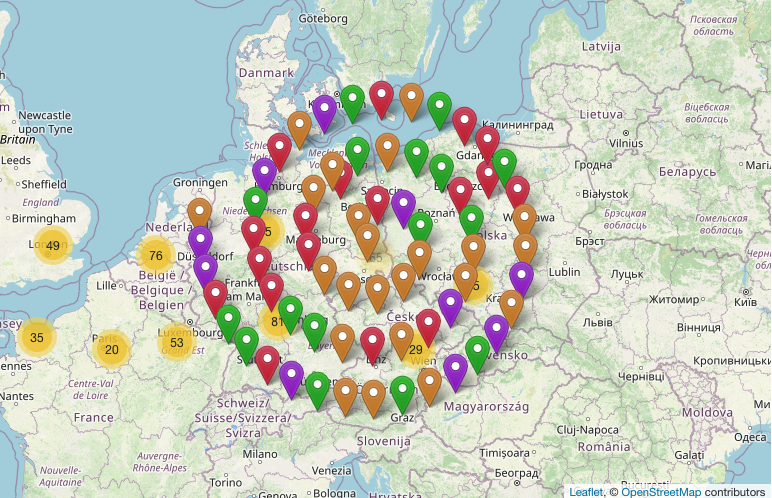
Many markers on a map become confusing. You can cluster and shape them.
-
You can use Awesome markers.
-
You can group the elements on the map by criteria and show/hide them.
-
Create a «featured map».
-
Create an overview map with geo-locations provided in the pages and posts.
-
Get a tooltip when hovering over an element.
-
You can design a choropleth map.
-
You can display the map in fullscreen mode.
-
Reset the map.
-
Gesture handling
-
Manage your files for Leaflet Map.
-
Help to migrate from WP GPX Maps.
-
and more functions.
Included Leaflet Plugins
Leaflet Plugins
- leaflet-elevation: A Leaflet plugin that allows to add elevation profiles using d3js.
- Leaflet.GeometryUtil
- Leaflet.i18n: Internationalisation module for Leaflet plugins.
- leaflet-rotate: A Leaflet plugin that allows to add rotation functionality to map tiles
- Leaflet.AlmostOver: This plugin allows to detect mouse click and overing events on lines, with a tolerance distance.
- @tmcw/togeojson: Convert KML, GPX, and TCX to GeoJSON.
- D3: Data-Driven Documents
- Leaflet-providers: An extension that contains configurations for various tile providers.
- Leaflet.Control.Opacity: Makes multiple tile layers transparent.
- Leaflet.markercluster: Provides Beautiful Animated Marker Clustering functionality.
- Leaflet.MarkerCluster.PlacementStrategies: Styling Markerclusters.
- Leaflet.ExtraMarkers: Shameless copy of Awesome-Markers with more shapes and colors.
- Leaflet List Markers: A Leaflet Control for listing visible markers in the map.
- Leaflet.FeatureGroup.SubGroup: Grouping of Leaflet elements by options and features.
- Leaflet.Control.Layers.Tree: A Tree Layers Control for Leaflet.
- Leaflet Control Search: Search Markers/Features location by option or custom property.
- leaflet-choropleth: Choropleth plugin for Leaflet (color scale based on value).
- leaflet.zoomhome: Provides a zoom control with a «Home» button to reset the view.
- leaflet.fullscreen: Simple plugin for Leaflet that adds fullscreen button to your maps.
- Leaflet.GestureHandling: A Leaflet plugin that allows to prevent default map scroll/touch behaviours.
- turf: Advanced geospatial analysis for browsers and Node.js
Included Font
Documentation
Detailed documentation and examples in German and English.
Thank you
Many thanks to everyone who found errors and provided ideas for new functions.
Capturas


Instalación
- First you need to install and configure the plugin Leaflet Map.
- Then install this plugin.
- Go to Settings – Leaflet Map – Extensions for Leaflet Map and get documentation and settings options.
FAQ
-
Is there a widget or other support for the editor?
-
- Unfortunately both plugins – Leaflet Map and Extensions for Leaflet Map – only work with shortcodes.
- If you have any questions please ask in the forum.
-
My gpx file is not displayed!
-
- Is the URL correct?
- Does the webserver return the correct mime type (application/gpx+xml)?
Put in your.htaccess:
AddType application/gpx+xml gpx

RewriteRule .*\.gpx$ - [L,T=application/gpx+xml]
-
It doesn’t work!
-
-
Are you using any caching plugin? Try to exclude at least these js files from caching:
- /wp-content/plugins/extensions-leaflet-map/leaflet-plugins/leaflet-elevation-*
- /wp-content/plugins/extensions-leaflet-map/leaflet-plugins/leaflet-gesture-handling-*
-
Are you using any plugin to comply with the GDPR/DSGVO? There might be a problem with that.
- If you use a caching plugin and a GDPR/DSGVO plugin you need to distinguish whether the user has accepted the cookie or not.
- Please ask in the forum!
-
-
Apropos GDPR/DSGVO
-
- If you need a plugin for this try DSGVO snippet for Leaflet Map and its Extensions.
- If you use Complianz | GDPR/CCPA Cookie Consent see here.
Reseñas
Colaboradores y desarrolladores
«Extensions for Leaflet Map» es un software de código abierto. Las siguientes personas han colaborado con este plugin.
Colaboradores«Extensions for Leaflet Map» ha sido traducido a 4 idiomas locales. Gracias a los traductores por sus contribuciones.
Traduce «Extensions for Leaflet Map» a tu idioma.
¿Interesado en el desarrollo?
Revisa el código , echa un vistazo al repositorio SVN o suscríbete al registro de desarrollo por RSS.
Registro de cambios
5.3 / 260619
- revised shortcode hover and the hover option opacity